-

-
Now that I have such a jack of all trades bike like the concours I find myself trying to plan rides all over the place that I've never been. Using some of the various ride planner sites I found a GREAT road yesterday but got completely lost in the process out in far east Portland/Sandy area.
So long story short I'm looking for a GPS setup as cheap as possible. I don't care if it's bike specific and or waterproof. I can figure out the mount stuff I'm sure as the Heli risers I installed have the Ram mount option. What I'm most concerned with is the ability to either load rides from sites like the Harley ride planner and custom make rides using an app or PC and inputting them to the GPS unit. I have zero use for I'm going to point b from a how do I get there, only interested in pre planned ride directions. Any suggestions on which brands/models fit this type of use? Would love something that has an Ipad app to make ride plans.
Thanks for any feedback all help is appreciated. It's just so damn daunting jumping in this GPS pool as there are so many options.
-
-
I had trouble with this same thing. There doesn't seem to be an simple solution. My GPS will import a route as individual waypoints and is stupidly confusing.
If you go with a Garmin, Basecamp seems the best software option, and after some quick googling, I found the post below in regards to models that support routes.
If there's a simple, easy way to do this, I'd love to know as well.QuoteI got the 2460 LMT for $199 from Costco. It does support the migration of routes created on basecamp or mapsource to GPS.
Below is the reply i got from Garmin Support:
Message:
Please let me know which models of Garmin nuvi supports using routes transferred from basecamp/mapsource?
Answer:
nuvi 2200, 2300, 2400, 2405, 2505, 3400, 3500, or 3700 series, LIVE 1695, LIVE 2300 series, or a deal device
nuvi 465, 500, 700, 705, 800, 805, 1400, 1690, or 5000 series, or a zumo
http://forums.gpsreview.net/discussion/25243/looking-for-auto-navigation-gps-with-custom-routing-2455lmt/p1
-
-
I had trouble with this same thing. There doesn't seem to be an simple solution. My GPS will import a route as individual waypoints and is stupidly confusing.
If you go with a Garmin, Basecamp seems the best software option, and after some quick googling, I found the post below in regards to models that support routes.
If there's a simple, easy way to do this, I'd love to know as well.
http://forums.gpsreview.net/discussion/25243/looking-for-auto-navigation-gps-with-custom-routing-2455lmt/p1
Thanks for the link, good thread. It seems finding good comparison's and info on these suckers is spotty at best.
-
-
Might find something helpful here.... http://www.zggtr.org/index.php?board=39.0
-
only interested in pre planned ride directions.
I have not tried many units myself, but I think daytime visibility is the number one limiter. Motorcycle-specific units appear to have a stronger backlight that allows them to be seen better in strong sunlight, though not without some effort in full sun where I can't see phone screens or my car's Garmin nuvi 300. I can see my Tom Tom Rider 2013 edition ($350 or so at Amazon, including mount to a RAM 1" ball) in full sun as long as no direct reflections from things on the bike, like the plastic window on the tank bag, cast a direct reflection on the screen, so positioning is important.
I don't know if the $600+ units like BMW and Zumo are any better. I'd like to think so but, then again, they may be just overpriced. It would be interesting to hear if anyone has compared the cheapos with the expensive ones.
The Tom Tom Rider comes with a program called "Tyre for Travel" that allows you to define a route by waypoints. It operates as a shell on Google Maps and can import Garmin, Google Earth and BMW files, and export to Google Earth and other formats, which is great to do a fly-through to check the planned route. The program takes some getting used to but it works once you get some practice. It is developed and maintained by a guy in the Netherlands with frequent updates and bug fixes. It is definitely a one-man operation. Look for some you-tube videos.
I thought I had made a mistake when I bought it, but after a few trials and a first trip I am satisfied with it. Definitely does what you are asking for. My opinion is just a data point; Keep researching until you find what works for you and post back if you have any question about my setup. Safe riding.
-
-
Search is your friend mate. Ive posted a dang good waterproof setup in a couple different threads using a Nuvi 2557 and a RAM Aquabox.
-
-
I am in the middle of finding my next GPS and was looking at the Tom Tom- the only thing I know for sure is that there on- line presence and descriptions are terrible. That aside, I wonder if I could ask a couple of questions:
1) Does it play MP3 (or any music) files?
2) Does it connect to a cell phone via Bluetooth?
3) Does it have an audio output jack?
Thanks,
BrianI have not tried many units myself, but I think daytime visibility is the number one limiter. Motorcycle-specific units appear to have a stronger backlight that allows them to be seen better in strong sunlight, though not without some effort in full sun where I can't see phone screens or my car's Garmin nuvi 300. I can see my Tom Tom Rider 2013 edition ($350 or so at Amazon, including mount to a RAM 1" ball) in full sun as long as no direct reflections from things on the bike, like the plastic window on the tank bag, cast a direct reflection on the screen, so positioning is important.
I don't know if the $600+ units like BMW and Zumo are any better. I'd like to think so but, then again, they may be just overpriced. It would be interesting to hear if anyone has compared the cheapos with the expensive ones.
The Tom Tom Rider comes with a program called "Tyre for Travel" that allows you to define a route by waypoints. It operates as a shell on Google Maps and can import Garmin, Google Earth and BMW files, and export to Google Earth and other formats, which is great to do a fly-through to check the planned route. The program takes some getting used to but it works once you get some practice. It is developed and maintained by a guy in the Netherlands with frequent updates and bug fixes. It is definitely a one-man operation. Look for some you-tube videos.
I thought I had made a mistake when I bought it, but after a few trials and a first trip I am satisfied with it. Definitely does what you are asking for. My opinion is just a data point; Keep researching until you find what works for you and post back if you have any question about my setup. Safe riding.
-
-
I am in the middle of finding my next GPS and was looking at the Tom Tom- the only thing I know for sure is that there on- line presence and descriptions are terrible. That aside, I wonder if I could ask a couple of questions:
1) Does it play MP3 (or any music) files?
2) Does it connect to a cell phone via Bluetooth?
3) Does it have an audio output jack?
Thanks,
Brian
Not that you asked about the Garmin, but the 765 does all that.
-
-
Yep, I have a 765T and the cable connection between the cable and the cradle is shot. Besides that, I could never see the screen in daylight on the bike anyway so I am looking for something considerably brighter. I have a Zumo 550 that I use but I need a back up GPS for the bike and depending on what I end up with, the Zumo 550 might end up being the back up.
BrianNot that you asked about the Garmin, but the 765 does all that.
-
-
Well I burned up some battery power searching around and narrowed the search down to the Garmin Nuvi 2597 and Garmin Nuvi 2557. I looks like these both do everything I need with the slight lean going to the 2597 with it having bluetooth that would work nice with the Sena Im planning on down the road. Price seems reasonable at 172 on amazon.
As for the length of the Ram mount arm seems like most are using the 2 or 3 inch length one correct? Seems like the 6 inch lenth arm would be a little over kill.
Thanks for everyones input!
-
-
I have the Zumo 660 and am quite happy with it.


-
...
No MP3 capability directly from the GPS. It may be possible to play from the phone. Never tried it.
1) Does it play MP3 (or any music) files?
2) Does it connect to a cell phone via Bluetooth?
3) Does it have an audio output jack?
...
It connects to the phone via Bluetooth for hands free calls. IDK if all phones. Some take up two connections.
No audio output jack. No SD card. Just a USB 2.0 to charge and data transfer.
-
-
I use my iPhone with the Garmin app... I just couldn't justify a stand-alone unit, when I already have a device capable of GPS (and music playback). That said, I only use it via audio when I'm on the bike... iPhone+sunlight=heat/shutdown (yes, that qualifies as a "con"). I used it on a ride to Yellowstone a couple summers ago... and it only tried to take me down a field in Eastern Oregon once.
In case anyone was wondering, the Garmin app was $50, and downloads the maps to the phone... so it's not receiving cell data the way some of the other phone-based apps do. I think they offer it for Android. GPS also takes a lot of juice, so the phone stays plugged in while in operation.
-
-
I use my iPhone with the Garmin app... I just couldn't justify a stand-alone unit, when I already have a device capable of GPS (and music playback). That said, I only use it via audio when I'm on the bike... iPhone+sunlight=heat/shutdown (yes, that qualifies as a "con"). I used it on a ride to Yellowstone a couple summers ago... and it only tried to take me down a field in Eastern Oregon once.
In case anyone was wondering, the Garmin app was $50, and downloads the maps to the phone... so it's not receiving cell data the way some of the other phone-based apps do. I think they offer it for Android. GPS also takes a lot of juice, so the phone stays plugged in while in operation.
I have this app also, great thing to have if you have a bluetooth headset. All of the turn by turns are boomed into your headset which means less time spent looking down on a GPS. I also have a Garmin 205 ($20 on amazon) that I use as a visual backup on a FirstGear GPS tank bag.
-
-
I use my iPhone with the Garmin app... I just couldn't justify a stand-alone unit, when I already have a device capable of GPS (and music playback). That said, I only use it via audio when I'm on the bike... iPhone+sunlight=heat/shutdown (yes, that qualifies as a "con"). I used it on a ride to Yellowstone a couple summers ago... and it only tried to take me down a field in Eastern Oregon once.
In case anyone was wondering, the Garmin app was $50, and downloads the maps to the phone... so it's not receiving cell data the way some of the other phone-based apps do. I think they offer it for Android. GPS also takes a lot of juice, so the phone stays plugged in while in operation.
No love from Garmin for Android. They have several apps, but none of them are GPS navigation for North America. I use CoPilot Premium for my Samsung Galaxy Note 3, I got it for $7.99 lifetime with North American maps on sale. It also downloads the maps on your smartphone, so it does not need a data connection to work. I've used it quite a bit on the bike and in the car or truck and it seems to work really well. I use a windows program (free) called Route Converter to convert routes that others have posted from Garmin or TomTom or whatever to Copilot format. I ride with my brother a lot and he uses a Garmin Zumo 550 and while it does not have some of the extra bells and whistles that the Zumo has, I believe it works almost just as well.
-
-
Well I burned up some battery power searching around and narrowed the search down to the Garmin Nuvi 2597 and Garmin Nuvi 2557. I looks like these both do everything I need with the slight lean going to the 2597 with it having bluetooth that would work nice with the Sena Im planning on down the road. Price seems reasonable at 172 on amazon.
As for the length of the Ram mount arm seems like most are using the 2 or 3 inch length one correct? Seems like the 6 inch lenth arm would be a little over kill.
Thanks for everyones input!
The 2597 or 2557 will probably not work with your Sena. They will only connect to a phone as a hands-free device. You have to have a GPS that is designed to work that way, and in the Garmin line it's pretty much the Zumos and the 765.
This is one of the things that really turns me off about Garmin: They refuse to make a single GPS that does everything a person might need. Instead, they make dozens of models that do specific things, forcing people to buy multiple units (one for hiking, one for the car, one for the bike, etc). I understand why they do this, but in this day and age where they are competing with Smartphones and apps, they're shooting themselves in the foot. I probably won't buy another high-end Garmin.
-
-
Bada- bing! Give that man a cheroot.
I am in the exact same place: I need a new GPS but am choking on the fact that a new Zumo, top of the line as it may be, is $800 and does not have any buttons on it. Garmin is not quite in step with the concept that they should make what customers would want / use rather than expecting the customer to choke down whatever is offered to them.
But the good news is that for that amount of money, there are sunlight readable, hardened tablets coming to the market that run Windoze: a coup of Streets & Trips and a USB based GPS receiver, all for well under $100, and it will not only be an outstanding GPS but much, much more versatile as well. They times they are a' changin'.
BrianThe 2597 or 2557 will probably not work with your Sena. They will only connect to a phone as a hands-free device. You have to have a GPS that is designed to work that way, and in the Garmin line it's pretty much the Zumos and the 765.
This is one of the things that really turns me off about Garmin: They refuse to make a single GPS that does everything a person might need. Instead, they make dozens of models that do specific things, forcing people to buy multiple units (one for hiking, one for the car, one for the bike, etc). I understand why they do this, but in this day and age where they are competing with Smartphones and apps, they're shooting themselves in the foot. I probably won't buy another high-end Garmin.
-
-
I played around with this for a bit today and figured out a relatively simple way of making this work. I'm using a Garmin Nuvi 2555LMT that I got off of Woot.com for around $80 a couple of months ago and the Garmin Basecamp software I downloaded for free from the Garmin site.
I created multi-day trip after playing with Basecamp for a couple of days. Once that was set, I plugged in the Nuvi and exported each day's route to the memory card on the GPS. Simple enough.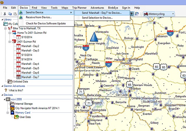 [/url]
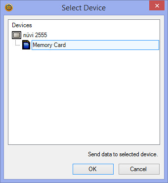
You can see the entire mult-day route here.
Here's how it looks on the GPS.
A route for one of the days.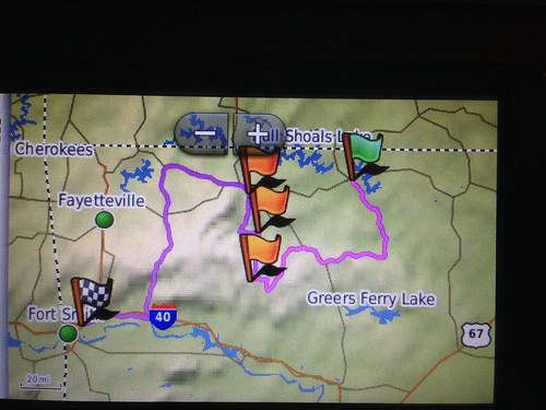
Hopefully this will help or at least answer some questions? Feel free to PM me if you want.
-
-
I haven't played around with basecamp yet but it looks like just what I'm looking for. Still weighing a few options, but I'll check out the woot site for some deals.
On a side note, took the Warrior out for a ride today and took more than a bit of getting acclimating too. I don't know if the C14's brakes are that incredible (yes they are!), or my Warrior has been sitting too long but damn the brakes felt like wood compared to the concours.
Thanks for all the help everyone, feel like I can make an educated decision now.I played around with this for a bit today and figured out a relatively simple way of making this work. I'm using a Garmin Nuvi 2555LMT that I got off of Woot.com for around $80 a couple of months ago and the Garmin Basecamp software I downloaded for free from the Garmin site.
I created multi-day trip after playing with Basecamp for a couple of days. Once that was set, I plugged in the Nuvi and exported each day's route to the memory card on the GPS. Simple enough.[/url]
You can see the entire mult-day route here.
Here's how it looks on the GPS.
A route for one of the days.
Hopefully this will help or at least answer some questions? Feel free to PM me if you want.